
How AI Is Transforming Daily Work in Service Teams
Reduce downtime and improve service efficiency with AI-powered troubleshooting. Learn how service teams use ilean to solve problems faster and capture knowledge.
InfoDrainage is a drainage design software platform that enables the design of Sustanaible Drainage Systems (SuDS), Green Infrastructure and traditional drainage systems. Both storm and foul networks are supported, permitting 1D and 2D simulations of multiple storms simultaneously.
There are two different tiers for InfoDrainage, Standard and Ultimate. InfoDrainage Ultimate provides all the functionality of the Standard version plus 2D analysis and Civil 3D integration. In the following lines, we go over those features, explain some of the limitations of the Standard version and provide alternative workflows if available.
InfoDrainage Ultimate
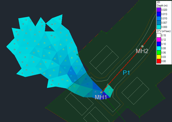
2D analysis can be performed to evaluate the flood risk to property or people during an extreme event, displaying the depth and velocity of the exceedance flows in a plan view.
InfoDrainage Standard
This feature is only available in InfoDrainage Ultimate.
InfoDrainage Ultimate
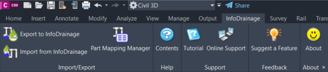
Civil 3D pipe networks, surfaces and catchments can be easily exported to InfoDrainage using a dedicated ribbon, available for Civil 3D 2020 and newer versions. The network can be exported from Civil 3D as a storm or a foul network, and parts mapping can be utilised to select the InfoDrainage connections and junctions that will replace the Civil 3D pipes and structures. This mapping will be remembered if there are multiple iterations between InfoDrainage and Civil 3D, and templates of this correlation can also be saved for use in other drawings.
The import process can create a new pipe network in Civil 3D or update an existing one, facilitating the synchronization of any changes in the design. If the network in InfoDrainage contains some elements with no equivalent structure or pipe in Civil 3D (such as ponds, swales, cellular storage, or open channels), those items will be included in Civil 3D using polylines, feature lines, corridors, and surfaces. Connections with multiple barrels are also supported and will be represented as multiple pipes in Civil 3D.
InfoDrainage Standard
InfoDrainage Standard doesn’t include a dedicated ribbon in Civil 3D. Although it is possible to transfer some InfoDrainage objects using an intermediate file format, such as AutoCAD, LandXML or a shape file, it is often required to manually update and even model those objects in Civil 3D. Additionally, updating Civil 3D objects (e.g. pipe diameters or slopes) can only be done by hand in Civil 3D using the Standard version.
While the Ultimate version will export all the objects (pipe networks, surfaces, and catchments) and their properties at once, using the Standard version requires exporting each object from Civil 3D to an intermediate file format and then importing that file from InfoDrainage.
For pipe networks and surfaces, it is possible to use the LandXML format. A minor inconvenience is that Pipe and Structure names in Civil 3D and InfoDrainage will not match exactly (e.g. “MH1” in Civil 3D vs “MH1 (SWS)” in InfoDrainage, “SWS" being the network name). If LandXML doesn’t provide satisfactory results for the pipe network, an alternative can be to export to a CAD format. This will export the pipe network as a 2D polyline in AutoCAD, requiring the creation in Civil 3D of the pipe network from it, and the input of the appropriate levels, and pipe and structures sizes manually.
Civil 3D catchments cannot be directly imported into InfoDrainage Standard. The Civil 3D drawing needs to be exported to an AutoCAD format first and then the catchments can be imported from that file. Since the catchments will be generated in InfoDrainage from polylines, the catchment names and runoff coefficients need to be manually edited to meet the values of the Civil 3D catchments.
When importing from an InfoDrainage file into an existing Civil 3D drawing using InfoDrainage Ultimate, it is possible to update existing objects or to create them new. This is particularly useful to update the diameters, slopes and other dimensions of existing pipes and structures. Additional branches can be added or existing ones removed from a Civil 3D network to match up the InfoDrainage file. This is not possible using the Standard version, you would need to look for those changes by comparing the two networks by hand.
Pipe networks and surfaces can be imported to Civil 3D using the LandXML format, in a similar way to how you would export them. Stormwater Controls (e.g. pond, swale, cellular storage…) and non-pipe connections (e.g. channel) are not included in the LandXML file and need to be imported separately. A shape file can be used to import them from Civil 3D as 2D polylines. The objects would then need to be modelled using Civil 3D tools. The InfoDrainage Ultimate ribbon brings them directly as 3D objects using feature lines and surfaces.
Catchments can be imported to Civil 3D as 2D polylines using a shape file. You then need to create each catchment from a polyline, rename them, assign a structure, and update the runoff coefficient using the values from InfoDrainage.
Reduce downtime and improve service efficiency with AI-powered troubleshooting. Learn how service teams use ilean to solve problems faster and capture knowledge.

Cybersecurity risks are not always caused by sophisticated attacks or major system failures. In many cases, risk builds quietly through everyday habits, overlooked processes, and limited visibility into where data is stored or how users interact with systems.

Learn how to reduce cyber risk through stronger security foundations. This month's bulletin covers home office security, legacy technology risks, vulnerability management, MFA, and cybersecurity best practices.