
How AI Is Transforming Daily Work in Service Teams
Reduce downtime and improve service efficiency with AI-powered troubleshooting. Learn how service teams use ilean to solve problems faster and capture knowledge.
InfoDrainage is a drainage design software platform that enables the design of Sustainable Drainage Systems (SuDS), Green Infrastructure and traditional drainage systems. Both storm and foul networks are supported, permitting 1D and 2D simulations of multiple storms simultaneously.
In the following lines, we will describe some of the main features of InfoDrainage and its seamless integration with Civil 3D.
Initial Assessment
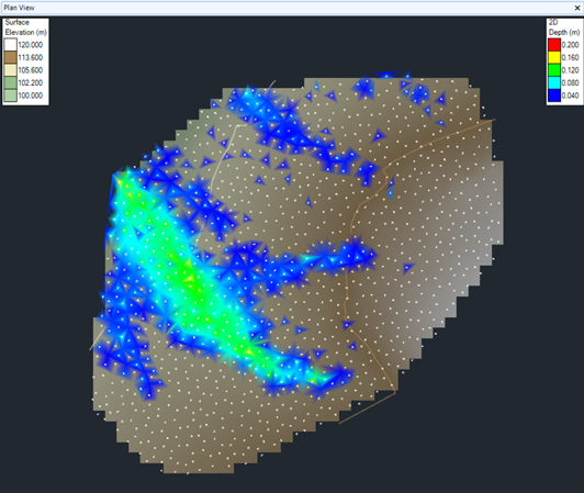
InfoDrainage provides a number of tools to assist in the early stages of the design process. The “Deluge” functionality can help to quickly recognise overland flow patterns. You can apply an amount of rainfall to the ground surface and identify where the water would accumulate after a time of simulation.
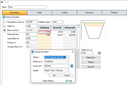
Another valuable feature in this phase is the quick storage estimate calculator. Given the inflows, discharge, and infiltration rates in an attenuation pond, a lower and an upper bound for its required volume will be calculated, offering a useful guide to establish a starting point for the detailed design.
Creating the network
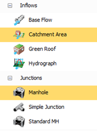
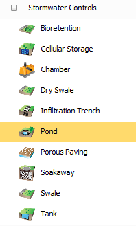
InfoDrainage makes available a variety of inflows, junctions, connections, and stormwater controls. For greater flexibility, custom objects can also be created and saved for future use.
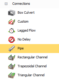
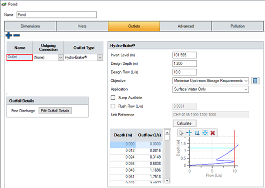
An assortment of outlets can also be utilised to control the flow that can be allowed to leave the stormwater controls, such as flap valves, gates, pumps, siphons, weirs, or hydro-brake flow control devices.
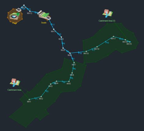
The drainage network can be created from Civil 3D pipe networks and catchments, using MicroDrainage files, or with InfoDrainage drawing tools. CAD, GIS or image data can be overlaid in order to convert or snap to existing geometry, and junctions and connections can be renumbered along the different flow paths.
Design Flows
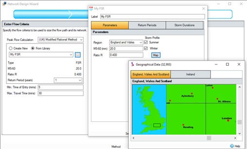
To consider the different storm durations and determine the flows for the corresponding return periods, standard methods and parameters that comply with UK regulatory requirements are available. These include the UK modified rational method, the seasonal Cv values required by the Wallingford Procedure with FSR and FEH rainfall methods, the ReFH2 Unit Hydrograph, the option to reduce the infiltration rate in an infiltration trench during analysis by dividing it by a safety factor, or the ability to specify the percentage impermeable in each catchment area to demonstrate compliance to approving authorities. Pollutants can also be added, and its concentration can be tracked along the network.
Analysis
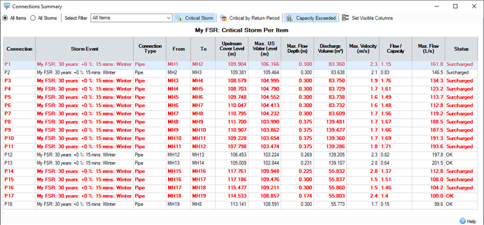
The network can be simulated with multiple storms simultaneously and filters can be applied on the results to identify the critical storm and the connections where the capacity has been exceeded.
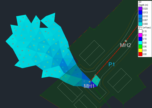
2D analysis can also be performed to evaluate the flood risk to property or people during an extreme event, enabling to display the depth and velocity of the exceedance flows in a plan view.
Reporting
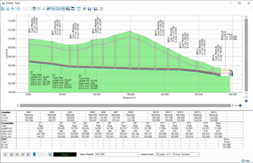
Several summaries, reports and graphs can be presented and exported to various formats, such as AutoCAD, Excel, PDF, and image file types.
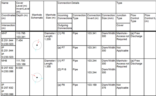
In particular, the Manhole Schedule has been formatted to comply with industry standard templates, with the inclusion of the Manhole Schematic.
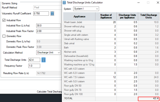
Foul Networks
Along with storm networks, foul networks are also supported to simulate domestic and industrial flows. Typical flows per dwelling and appliance types are provided to assist in the estimation of the flows, and standard methods like the optimisation to proportional velocity at 1/3 flow are available.
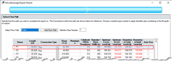
MicroDrainage File Support
InfoDrainage supports the import from MicroDrainage of network designs (MDX), MDSuDs designs (MDSX) and source control designs (SRCX/CASX). Flow paths from Infodrainage can similarly be exported as an MDX file.
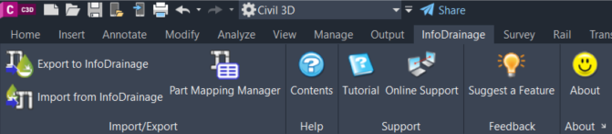
Civil 3D Integration
Civil 3D pipe networks and catchments can be easily exported to InfoDrainage using a dedicated ribbon, available for Civil 3D 2020 and newer versions. The network can be exported from Civil 3D as a storm or a foul network, and parts mapping can be utilised to select the InfoDrainage objects that will replace the Civil 3D pipes and structures. This mapping will be remembered if there are multiple iterations between InfoDrainage and Civil 3D, and templates of this correlation can also be saved for use in other drawings.
The import process can create a new pipe network in Civil 3D or update an existing one, facilitating the synchronisation of any changes in the design. If the network in InfoDrainage contains some elements with no equivalent structure or pipe in Civil 3D (such as ponds or open channels), those items will be included in Civil 3D using polylines, feature lines, corridors, and surfaces. Connections with multiple barrels are also supported and will be represented as multiple pipes in Civil 3D.
To learn more about Civil3D, visit our product page, or call us on 0345 370 1444 or email info@symetri.co.uk.
Reduce downtime and improve service efficiency with AI-powered troubleshooting. Learn how service teams use ilean to solve problems faster and capture knowledge.

Cybersecurity risks are not always caused by sophisticated attacks or major system failures. In many cases, risk builds quietly through everyday habits, overlooked processes, and limited visibility into where data is stored or how users interact with systems.

Learn how to reduce cyber risk through stronger security foundations. This month's bulletin covers home office security, legacy technology risks, vulnerability management, MFA, and cybersecurity best practices.